This hilly, circular walk has some interesting views. The walk was submitted by Guildford Rambling Club and appears in the January issue of VantagePoint. However, due to COVID, there is now a small diversion, so please use this version! (www.guildfordramblingclub.org.uk)
From the car park, continue along the road as it dives under the A3. Walk about 3/4 mile, passing Begley Farm, to reach Boundless Farm*. Just before the farm gate turn right through a barrier into forestry commission land and take the left hand track to run along the back of the farm ignoring all turns to the right. Reach a T junction with a barrier. Go through it onto the access track of a large house. Immediately to your left is a 2 way signpost, both options being to the left. Take the right-most choice and walk through to High Button Road. Turn right and walk along the roads which climbs up, passing, on your left-hand side, Hurthill Copse, to reach its end by High Button Cottage.
Continue forward on a path up through trees, still climbing. Eventually reach a post with yellow and blue arrows. Pass this and in 15 metres reach a small stubby post. This time break away left for 5 yards to a T junction with a track which you follow to the right. Climb up and continue straight on, going straight through several signed cross paths and ignoring other lefts and rights. Eventually drop down and, at the bottom, arrive at a junction. Go straight on, through a metal barrier onto a wide track which soon becomes a tarmac road. About 200 yards further on, take a footpath left. Just passed “Ormiston Lodge” the track forks, Choose the right hand fork to mount a track.
Follow this track uphill until it reaches the top and bends sharply left. Here, take a path right then immediately left along a fence. (Do not take the downhill path)This emerges through a screen of trees to a cross path. Continue straight ahead to reach a lane where you turn right and emerge at a bend in a road. Turn left down Weycombe Road and walk about 1/2 mile down the road, passing three roads on your left the last being Bartholemew Close and taking the next turn left into The Spinney. Follow this road past a small cemetery and take the marked footpath on your right between two fences to reach a railway bridge. Turn left to cross it and then cross the road right, into Pathfields, to walk past some houses and reach Chestnut Avenue car park.
To get to the centre of Haslemere, cross to the far right corner and exit through an alleyway. Reach the road and turn left to walk down to the High Street. There is a pub more or less opposite and there are cafés to the left. To get to a picnic spot, cross the High Street and walk left. Turn right and walk up Well Lane. At its end, find the old town well and the grassy picnic area and benches can be found on the right.
After lunch return to Chestnut Avenue car park. Leave through the back corner of the car park following the Greensand Way and retrace your footsteps back to the railway bridge. Cross and turn left to go over the railway bridge. Go right, beside St Bartholemew’s church, uphill along High Lane. Continue up until, just past the Pine View Close / Weydown Road crossroads, take a footpath left and drop down through trees to another road and turn right. After 150 yards, take an un-named lane left, opposite Inval Lane. Walk up to the dead-end at the top, by Deer Path Cottage. Turn right and follow the path straight to a 4 way signpost.
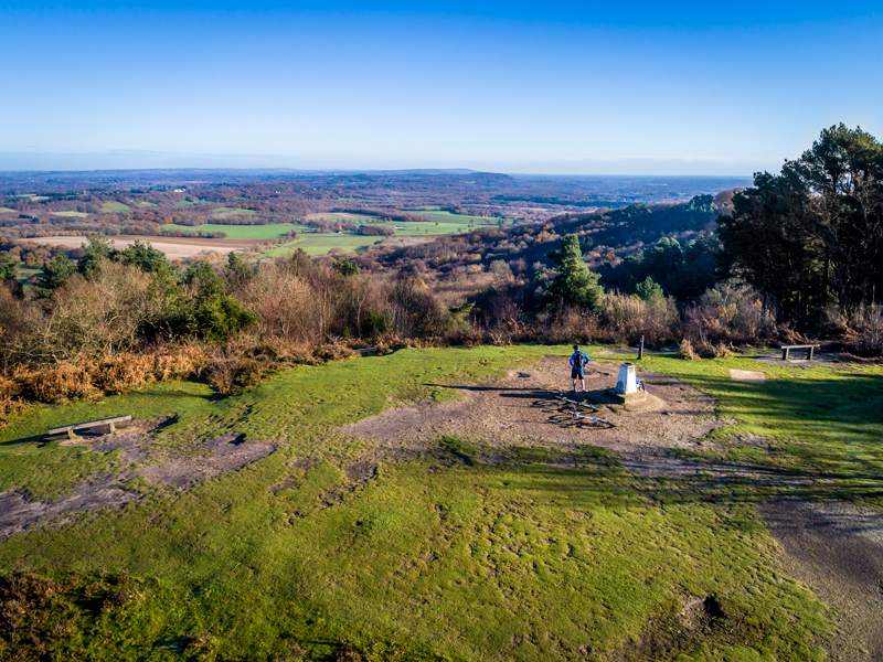
Take a bridleway left and continue ahead on this wide path as it twists and starts to climb. Ignore a fork right and, just beyond it, enter NT land again through a gate. Follow this wide path up into trees and at a junction, fork left and keep going until passing through another gate. Immediately thereafter reach cross-paths. Take the path second left, and climb steeply up onto Gibbet Hill, with its monument to a murdered sailor and a trig point and, of course, splendid views. Go past the monument to pick up the tarmac Quiet Road and follow it right for ¾ mile to its end and beyond. A lane merges in from the left. Either:
- For views into the Devil’s Punch bowl, turn left just beyond this point up a track signed “Unsuitable for motor vehicles”. Continue up and over the top and on until encountering, on the right-hand side, a green metal barrier. Here, turn right. Follow the path down and on until reaching a T junction with a wide track. Turn right and walk through to the starting car park. Or,
- continue forward down the wide metalled lane, Punchbowl Lane, to reach the starting car park
* Due to covid restrictions it is no longer possible to walk through the farmyard
DISTANCE: 6 miles
OS MAP: Explorer 133
GRID REFERENCE: 899 378
STARTING POINT: The small car park in Boundless Road, near Thursley. From Guildford/London turn off the A3 for Thursley turn right and cross the A3. On the other side turn left then quickly left again down the start of the slip road up from the A3. A short way down here, turn right into Boundless Road. Drive about a mile to find a small car park (Punch Bowl Lane CP) on the right, immediately before the road dives under the A3.


