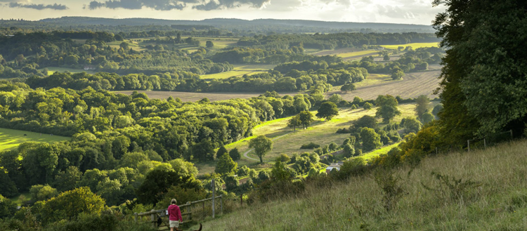
Denbies Hillside and neighbouring Ranmore Common are some of the richest chalk grasslands in south east England. The downs tumble towards to the pretty village of Westcott with beautiful views in all directions. Taken from www.nationaltrust.org.uk where a bigger map can be downloaded.
1. Leave the car park (marked 1 on the map) by the track just to the right of the noticeboard and swing further right once it gets into open space. You’ll soon enter the woods and head due south. Here the path swings slightly left and rises as it goes south through dense woodland of mainly silver birch. Walk straight on at the first cross path where the path begins to slope downwards.
2. Follow the track onwards and soon you’ll reach a cross path again (marked 2 on the map). You’ll see a sign post (remember this for your return journey) where you need to turn right (west) onto the North Downs Way. Continue in a westerly direction along the North Downs Way; in some places trees have fallen down across the track.
3. Just after the North Downs Way begins to head downhill, you reach a pillbox dating to the Second World War – this is marked 3 on the map. Close to the pillbox is a gate – go through this and take the left fork down the hill. You’ll leave the North Downs Way at this point. The track that you’re walking along here leaves the woods and slopes further downhill – on the left there is a magnificent view over Dorking and Box Hill and if you look hard left one can see the spire of St Barnabas church on Ranmore Common. About 100 metres down the slope there is a seat on the right – this is known as ‘God’s seat’. There are two versions of why it is called that. The first is that this is where God viewed his county of Surrey and the second is that if you are climbing the hill towards it, you may think “thank God I’ve made it”. At the bottom of the hill swing right on the track which then falls quite steeply and then swings left where you’ll come to a gate. Go through the gate and walk along the left hand side of the field and over the railway bridge. This is the Reading to Dorking line and is occasionally used by steam trains. Keep to the left hand side of the fields and to your left on the horizon you’ll see the spire of St Barnabas church on Ranmore Common again.
4. At the end of the fields you reach a crossroads (marked 4 on the map) by a large house – here you leave the track and go half left (45 degrees) on a footpath going uphill across the field, signed by a disc. At the far side of the field keep on the path through the gate onto the fenced path going uphill until you reach St John the Evangelist church. Stay on the path round the right of the church and you will come to a gate onto a hard surfaced road where you turn right then walk up the towards the A25 and the Wotton Hatch pub.
5. On leaving the pub (marked 5 on the map), cross the main road and walk back down the small road that you came up. Follow this for about 100 metres then turn off right into the field at the public footpath sign. Follow the fence down the right hand side of the field and go past the two ponds where the path is quite narrow.
6. Continue downhill, ignoring the path that goes off to the right, and at the bottom of the hill there is a house on the right hand side and a cottage straight in front of you (marked 6 on the map). At this point turn right onto the surfaced road (this is marked as a public footpath) and continue straight on for 400 metres. At the start of this section there is an open field to your right and woods to your left – at the end of the first open field on your left, turn left onto an unmade road.
7. Walk along this unmade road almost due north towards the downs until you pass Coombe Farm and a pond on your right where you reach ‘The Empty Box Company’. At this point swing right then left followed by, in about 100 metres, another right turn and then left turn under the railway bridge (marked 7 on the map). As you emerge look right and you will see the spire of St Barnabas church again. On the far side of the railway, walk along the track at the left hand side of the field until you reach a gate – go through the gate (where you will see the National Trust sign) and then turn right and you are now on a stretch called the ‘Carriage Way’. This was built in the mid 1800s by the Cubbitt family who at that time owned the Denbies estate. They used this stretch to show their guests what the surrounding countryside looked like. Walk along the Carriage Way at the bottom of the scarp slope – the hill you can see in front of you is Colley Hill. You are in buzzard country here so keep an eye in the sky to glimpse these magnificent birds. Recently there have also been sightings of red kites in the area.
8. Go through the first gate and the first set of woods, ignoring the bridle path. When you reach a ‘five ways’ (marked 8 on the map) take the second left track which goes up the hill. The hollow on your left is a disused lime kiln. Shortly after turning off the main track the path you are on splits – take the right fork (which is marked ‘The Denbies Nature Trail’) where it climbs quite steeply through some woods then passes through a gate into open hillside. The path cuts diagonally across the open downland. The buildings below you are Landbarn Farm, owned and managed by the National Trust. Due south from here if you look closely, you can see Leith Hill Tower on the horizon through a gap in the trees. At the fence line at the top of the downs turn left along the grassy path close by the fence – from this section the view to the left must be one of the finest of this part of Surrey (and some of Sussex).
9. Continue on this path, which rises gradually, until you reach the top left corner of the field where you will need to climb over a stile (marked 9 on the map) and turn left (ignoring the path that goes down the slope). You are now back on the North Downs Way, heading west. After about 700 metres you will reach the signpost that you saw at the start of your walk. Turn right here, head up the hill and the car park (marked 1 on the map) is about 500 metres along this track.
DISTANCE: 5.3 miles
MAP: OS Explorer 146 Dorking, Box Hill & Reigate
START: Ranmore West car park, RH5 6SY

Image: Southern view from Denbies Vineyard (Colin Miller/NT)


