
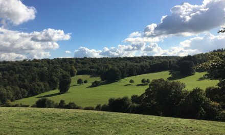
Abinger Roughs
This gentle stroll is a walk to be savoured, enjoying the delights as the woods come to life in spring. Abinger Roughs is known for its rhododendron ramble and the bluebells, and is also a wonderful place to listen out for songbirds in the spring and early summer.

1. From the car park take the path through the fence at the opposite end of the car park from the road. You’ll walk through some open woodland with some beautiful beech trees – their leaves in spring are a wonderful fresh green colour. Continue to follow the main path through grass. Some 300 yards from the start you will see some magnificent old beech trees on your left hand side. Look out for the Witches Broom tree. Just past here you will go down a small slope and meet a track crossing your path.
2. Following the sandy track you’ll see our 200 year old Scots and Corsican pine trees. We manage this area so that the best specimens grow strongest and tallest.
3. The Rhody Ramble sign points to the entrance into the rhododendron wood – a fantastic place for hide and seek. These rhododendrons were planted in the 19th century by Thomas Farrer of Abinger Hall. Over time they have become somewhat overgrown. From the Rhody Ramble sign, continue your walk along the main path so you can also see the bluebells. The path will come out in a wide open area.
4. You have reached the open glade. To your left, over the greensand ridge, rises the Hurtwood (an area of heath and forest). Continue to the edge of the glade and a junction of paths. Take the second fork to the left along a glorious undulating path curving to the right and rising to a path signposted “the Snowdrop Trail”. Follow the path downhill to a gate and then a bench where the path turns sharply right and, if you’re lucky, you’ll see the bluebells on either side of the path. You’ll pass through a gate and, keeping parallel to the hedge on your left, you’ll come to a T-junction by an open gate. Turn right here along the rough track and up the slope to the trees.
5. Turn right and go up the broad sandy path back to the edge of the wood, where there is a wonderful view of the North Downs. At the cross roads take the path marked by a Nature Trail marker, which goes down a slope with a fence on your left hand side.
6. Continue to follow the signs for the Nature Trail along the ‘Mayor’s path’. See the rhododendrons which were planted years ago to form a wilderness garden by Thomas Farrer, who owned the Roughs in the late 19th century. Follow the path through the rhododedrons until you come out into a wider more open area.
7. As you come out of the Rhododendrons you will see great views up to the North downs on your left. In front of you is the second patch of bluebells. The path bends round to the right and you will come out to some holly bushes on the main path. Turn left here to descend down the path.
8. Keep to the left path as you go through the narrow ‘neck’ of Abinger Roughs. Keep on the path that runs parallel to the fence. To your left are the North downs. Continue along the path as it goes thorough the woodland ignoring paths to the right. You will come out of the woods into a more open space.
9. In this open space, there are some memorials to life here in the past. The old farm to your left is Leaser’s Barn which has been used for lambing for centuries. The granite cross is the Wilberforce Memorial. Take a moment to stop and read the inscription. Then walk up the path running past the memorial and head back to the car park.
2 miles. Start: National Trust car park, White Downs Lane, Abinger Hammer. Nearest postcode RH5 6QS
Leith Hill woodland walk
Enjoy an exhilarating walk at Leith Hill, which has been a popular picnic spot since the 19th century.

1. From the carpark, cross the road and follow the orange marked trail into woodland.
2. This track leads you down through the woodland where, in the autumn, you can hear roving flocks of woodland birds including nuthatches, coal tits and treecreepers. ‘The Woodland Trail offers a lovely walk at all times of year with autumn being particularly stunning due to the the turning colours of the trees.’ Paul Redsell, Countryside Manager, Surrey Hills West.
3. At the junction of tracks take the second left through the Lime Avenue, planted as part of the original estate landscape. The path takes you past the walled garden on the right and to the road where you should turn left carefully heading down the road for 55yd (50m) before heading right into the farmland over the stile.
4. Follow straight ahead in front of Leith Hill Place on your right and admire the stunning views across the parkland and southwards over the Weald onto the ridge of the South Downs. Pass through the kissing gate and cross the second field to the gate just below the pond. Once through the gate you will pass through woodland. Bear right and follow the straight track ahead of you.
5. Follow this track which bends right and heads uphill. Bear right, following the signs which lead you through the rhododendron wood and up through the car park to the road.
6. Turn right from the car park and then left up a couple of steps, being careful when crossing the road. Once across the road follow the path heading left up alongside the sandstone wall. This path will lead you all the way up through woodland to the tower.
7. Reward yourself with some light refreshments from the servery whilst enjoying the stunning views of inner London looking north and the English Channel to the south, through Shoreham Gap some 25 miles (40km) away. To learn more about the area, and enjoy the spectacular panoramic view from the top battlements, why not enter the tower. To return to the car park head down from the tower, turning left with your back to the noticeboard following the rail around to the top of the steps. Carefully take the steps back to the car park.
2.5 miles. Start: Windy Gap car park, near Coldharbour village, Dorking, Surrey RH5 6LX.
Both walks are taken from the National Trust: www.nationaltrust.org.uk


