
This is a largely flat walk through fields and woods, passing an interesting old chapel. The walk description is provided by Guildford Rambling Club (guildfordramblingclub.org.uk).
1. From the parking area walk north along the road to reach the Kings Head. Take the footpath right that goes through the churchyard behind the pub and out of the back onto a lane. Turn right and walk past Highcroft Cottage. The lane becomes a path. Continue forward. At a cross track go straight on. At a 4-way signpost go straight on, through a gap in the hedge. Head straight out across the field then jink right and left to enter a wood. Go through the wood to reach and pass a house and continue forward along its drive to reach a 3-way signpost at a road.
2. Turn left. Immediately after a house is a 3-way signpost. Turn right and follow the Sussex Border Path along the right-hand edge of a field. Reach a concrete track and turn left along it. Follow this all the way to a road by Bury St Austen’s Farmhouse. Go straight across and through farm buildings and the concrete track continues all the way to Ridge Farm. Walk through the buildings and on to reach a road. Cross, jinking left and then turning right, along a footpath. Pass the side of Honeywood House and continue through trees and along its access track for ½ mile to reach a road. Turn left and walk for 100 yards to take a footpath right, into a field. Cross ½ left to a stile into another field. Walk up the right-hand side until forced left a little way and then turn right to continue forward.
3. At the bottom of the field, go over a stile and turn right to walk anticlockwise around the next field. Take the second stile right and follow the left-hand edge across and along in the edge of trees. At a 3-way signpost at a field corner go straight on and continue along field edges to pass through Rose Hill Farm to reach a road. Turn right and walk about 250 yards to find a footpath left, at the right-hand side of the entrance to Chapel House Farm. Follow the path along the left-hand field edge and then reach the pretty little Oak Hill Chapel (built in 1899) in the middle of a wood. At the porch turn left and walk along the ‘stepping stones’ path to go down steps and over a footbridge into a wood.
4. Turn right and immediately take the left-most of two more footbridges. Follow the track through the wood for ½ mile, ignoring all lefts and rights, until emerging on a road in Wallis Wood with the Scarlett Arms pub and green immediately to your right.
5. From the pub, go along the road to the right for 300 yards to reach a left turn to Oakwood Hill etc. Here, look for a footpath right, on the other side of the road. In the field head out half-left (crops or no crops) to reach a gate onto a road, about 100 yards to the left of a ‘tudor’ cottage. Turn left and walk along the road, following it as it swings right and passes Ewhurst Brick Works. After about 500 yards, find a footpath right and along a wide track. Reach some buildings and take a stile left, into a field. The path swings right and exits into trees and then is much overgrown for over ½ mile. At a big gate you are forced right, in a corridor alongside a fence. The path swings right, still in a corridor but now with a fence on the other side. You are forced left. At a yellow arrow go right and quickly cross a plank footbridge into a field.
6. Head out to the far left corner to exit. Go over another footbridge and reach a T junction with the drive of Hoopwick Farm. Cross and take a footpath right, into a field. Walk along the right-hand edge, ignoring a footbridge on the left. At the far side go through a gate into trees and continue forward. Emerge to walk along the right-hand side of a field. Go through a gate, right, onto a concrete track. This takes you across a field and continues in the next, after you have crossed two stiles. Follow the second section of concrete track straight out until almost reaching a high, green metal stake fence. Here, turn left and walk parallel to the fence. When it ends trend right to find a stile, right, at the edge of a garden of a house (Pollingfold Manor). Follow the path as it emerges on a drive and continue to a road.
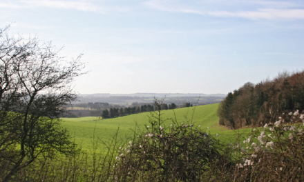
7. Turn left and walk for 100 yards to take a footpath right, along the track to Tillhouse Farm. Follow the track as it swings sharp left to pass the house and continue on into a field. Walk down the right-handside for about 300 yards to turn right, through a gap, into a large field. Head out across it half-left, aiming towards a large house, Maybanks Manor. Reach its drive and turn right to walk round towards another house, Ruet. The drive bends left close to the house and, on this corner, look for a kissing gate, on the left. Take this into a field and walk along its left-hand side. At the first corner, go forward through a clip chained gate into another field. Follow the path left and into the next field. Here, head half-left to a stile out onto a road.
8. Turn right and walk 100 yards to find a footpath left. Go over a rise and follow a fenced corridor to the left. Go over a stile and along the right-hand side of a field. Take a stile right, onto a path which you follow left, between gardens. Emerge on a road with a ‘Rudgwick’ sign immediately to your right. Turn right and walk to the start.
DISTANCE: 10 miles
OS MAPS: Explorer 134 Crawley & Horsham, Cranleigh & Billingshurst
STARTING POINT: Turn off the A281 north into Rudgwick and use a lay-by on the right, before you reach the Kings Head.

Image: Drive to Maybanks Manor and Ruet. Most of the drive is a public footpath. © Copyright Robin Webster


