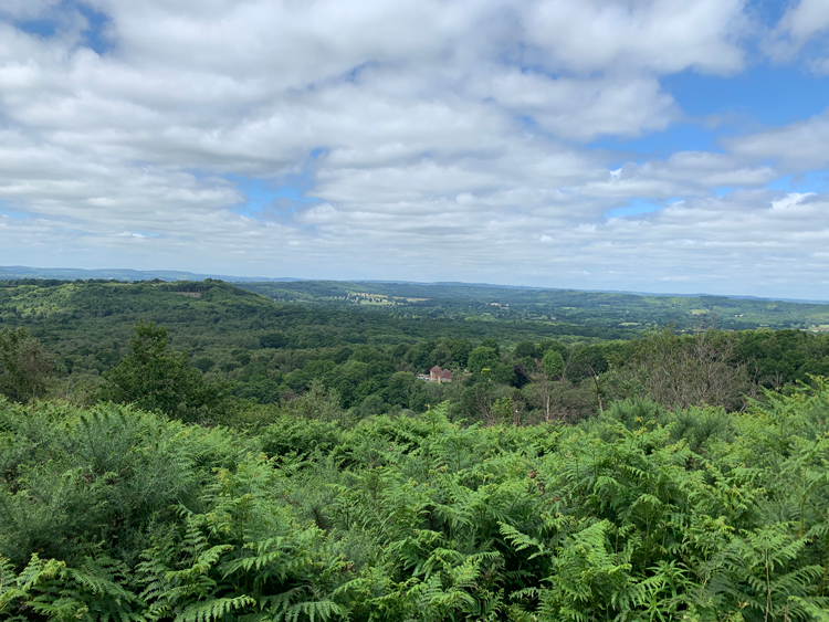
This is a pleasant walk with some lovely views. It starts from the Woolbeding carpark at Older Hill near Midhurst which itself has a magnificent vista as seen right. This is the first walk I have done using a new walking app called ViewFinder. If you get a premium subscription, it uses OS mapping at 1:25k and allows you to easily do your own walks which you can also record and then share with other users. You can download the maps offline and even add your own photographs. You can also use the app to find routes that other people have done which you can then walk yourself. SR
1. Take the footpath towards the back of the Woolbeding car park at Older Hill car park and turn left uphill along a rather rutted track until you reach a T-junction at the top. Turn left here along a shaded and tree-lined straight track. Keep on the track passing a two-way finger post. As you come to a right-hand bend by a gate to Pinehill House, take the left fork marked by a footpath post. At a three-way finger post turn right and carefully follow the path which goes very steeply downhill and emerges onto a metaled track with another three-way finger post.
2. Turn right and go straight ahead through an unneeded gate. Follow this wide footpath through pine trees as it meanders around the base of Telegraph Hill. Keep straight on, passing a number of finger posts. At the end of the wood you emerge into a field and the path kinks left by a finger post into a field. Keep straight downhill past a large oak tree. At the end of the field go past an unneeded style and into more woodland, following the fence line on your right. At a small clearing, the path turns left, still alongside the fence. You will pass a couple of houses up on your left hand side before coming out into another clearing and joining a metaled track. Stay on this track until you reach a road. You get some lovely views of Blackdown in the distance.
3. When you reach the road, turn right to shortly meet the main road (A286). Cross carefully and take the footpath almost opposite into woodland. At a three-way finger post keep straight ahead. The footpath isn’t very obvious but keeps close to the main road with some houses visible to the left. Shortly the footpath meets the main road again. Turn left along the verge past the sign to The Forge and then carefully cross the road to the driveway for Beeches Farm. Follow this driveway and continue past a finger post. At the next finger post, take the middle left footpath into the woods and climb fairly steeply uphill on a sunken path. Keep straight, passing a farm track with two stiles and you will shortly reach a road. Cross jinking right to rejoin the footpath through woodland. When you reach a small clearing at a finger post, take the middle path straight ahead. At a junction of paths, again keep straight ahead following the finger post. Shortly after you will come to a three-way finger post and here you want to turn right.
4. Keep straight following the finger posts and at a gate, veer left as indicated. Up on your right is the former King Edward the seventh hospital which is now been turned into luxury flats. Go through an unneeded gate and past the sign for Woolbeding Common. The footpath keeps close to the wall on the left hand side with a fabulous view on your left of the South Downs. At a three-way finger post keep straight ahead. You can in fact either stay on the footpath by the side of the wall or take the wider and more open track to the right. Both tracks emerge at a small cottage. Go past the cottage up a small incline and continue along the driveway until you reach another road. Cross, jinking right slightly, to rejoin the footpath which keeps to the left side of a large field. At a three-way finger post keep straight ahead to the end of the field.
5. You will reach a road and the pretty Tote Hill Cottage. Turn right along the road and keep straight past a camp site on your left until you reach Tote Hill Farmhouse. Follow the road ahead downhill before emerging into a small valley with pretty farmhouse up on your left. Pass a couple of houses on your right and keep on the track to go past the farmhouse, ignoring the public bridleway signposted to your right. Go past Ivy Cottage until you come to three-way finger post and keep on the track jinking very slightly to the right. At the next finger post, leave the track and take the first path into woodland, ignoring the footpath to your hard right also into woodland. This path goes through trees and soon opens up and becomes grassy underfoot. At a four-way finger post keep straight ahead.
6. Soon you will reach a small car park and the road. Cross over and take the footpath directly opposite uphill past the Woolbeding Common sign. Keep straight ahead, cross the single track lane and continue on the footpath uphill. At the top you will reach a clearing. Keep straight, go past a cottage and in a short distance you reach another cottage. Turn left here directly opposite the driveway and follow the track all the way until it meets the small road you have just crossed. Turn right here and follow the road until you reach the car park.
DISTANCE: 6.4miles MAP: OS Explorer OL33 Haslemere
START: The walk begins in the Woolbeding Common car park at Older Hill, which is off Linch Lane.
DIRECTIONS: From Midhurst; take the A272, then the right hand turning signposted Woolbeding. Follow the signs to Redford; the occasionally very narrow way becomes Linch Lane. The signposted turning to Older Hill is to your right hand, the National Trust car park is around 750 metres along to your right hand.


