This interesting walk takes you through woods and fields, up and down hills and offers some splendid views. It was submitted by Guildford Rambling Club (see guildfordramblingclub.org.uk)
Turn left along the road and walk about 300 yards to find a tunnel, on the right, under the A3. You will need to hop over the low safety barrier to go down steps and under the A3. On the other side, turn left and walk out into a field. Follow the path down the slope half-left to reach trees and a stile.
Climb over the stile and drop down left onto a track and follow it to pass the house at Hole Farm. Go out of the entrance gate and turn right. Quickly fork left to follow the wide track for about 1.25 miles. Along the way pass a lake, on your right, ignore a finger post pointing left and eventually emerge on a bend in a metalled lane. Blackhanger Farm is down to the right but you continue forward over Halnacker Hill, passing a lone house to reach a road.
Turn right and walk 350 yards, passing Halnacker Cottage, to reach a road junction. Here hook back left, signed to Brook. After about 0.25 miles, find a finger post pointing right. Follow this down and then on for over a mile, along a wide grassy corridor, sometimes along the left-hand side of fields and through a number of gates until you reach a T junction with a very wide corridor. You can see the large modern barns of Witley Farm away to your left.
Here, turn right and walk up and over slight rise and on until you reach trees. Immediately you will see, on your right, an information plaque for the site of a medieval moated manor house. There is a little island, covered in primroses and daffodils in the Spring. Continue on, quickly passing a pond on your left and swinging right to follow the path into a large field. Turn right and walk along its edge to a gate onto a metalled drive. To the left is a railway bridge but you turn right.
Walk a little way, almost to South Park Farm and, here, take a footpath left and into a field. Follow the path alongside the garden fence, around the end of the garden and though a gate. Turn left and follow the hedge along the grassy track to a railway embankment. The path takes you right, through a gate and up to emerge at the start of the drive to Damson Farm. Turn left and immediately go under a railway bridge. Continue along the track, passing scattered houses until eventually emerging on the Grayswood Road with All Saints Church and the green to your right and with the Wheatsheaf further along. You could picnic in the churchyard or on the green.
After lunch, walk past the pub a little way and turn right, down a private road. Just beyond the first house, take a path forking off to the right. Follow this down into trees and then up to reach and cross the railway line. On the other side, continue forward to reach a junction with a yellow arrow pointing left (towards Haslemere) and another pointing right, into a small field. Enter the field and go straight across and out onto a track. Turn left.
Now comes a steady one mile climb. You continue along the track, ignoring a faint fork right at a point where the track swings left. Reach a T junction with another track and turn right. Pass a lone house and ignore an immediate left. The track soon swings left and you follow it, ignoring a track right. Reach a fork and follow a yellow arrow right. The track climbs steeply and swings left. At a junction with a track heading off to the left and down, go right.
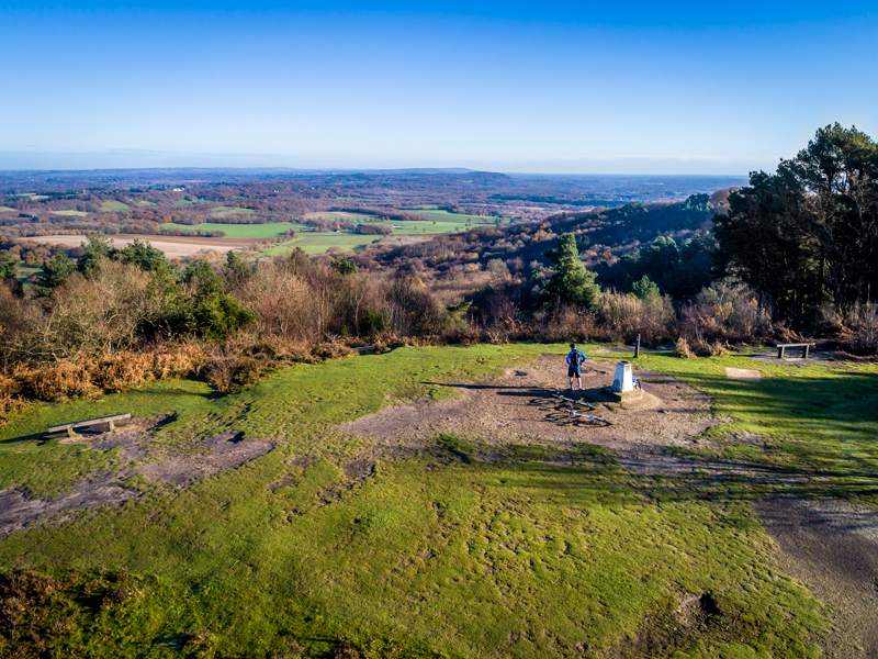
The track levels out and passes the site of the Temple of the Four Winds, which was a lodge built in 1910 by Viscount Pirrie. Continue on up and then down to a barrier at a 5 way junction. Ignoring a left turn and two forks right, go straight ahead and steeply up onto Gibbet Hill. There is a trig point here, also a memorial to a murdered sailor and splendid views. Go straight across and down onto the Quiet Lane, a metalled lane. Turn right to walk along it for about 0.75 miles to its end and then beyond. A lane merges in from the left.
Either:
(1) To see views down into the Devil’s Punchbowl, just beyond this point turn left up a track signed “Unsuitable for motor vehicles”. The Punchbowl will appear to your left. Continue up and over the top and on until encountering, on the right-hand side, a green metal barrier. Here, turn right. Follow the path down and on until reaching a T junction with a wide track. Turn right and walk through to the starting car park.
(2) Or, simply continue forward down a wide metalled lane, Punchbowl Lane, to reach the starting car park.

DISTANCE: 7.5 miles
OS MAPS: Explorer 133 Haslemere & Petersfield.
STARTING POINT: Car park in Boundless Road, nr Thursley.
HOW TO GET THERE: Turn off the A3 southbound for Thursley turning right to cross the A3. On the other side turn left then quickly left again down the start of the slip road up from the A3 (if coming north, this is on your left just after you turn off for Thursley). A short way down here, turn right into Boundless Road. Drive about a mile to find a small car park on the right, just before the Boundless Road dives under the A3.


