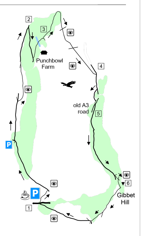
This family-friendly walk takes you along the rim of the Punch Bowl, across to the opposite side and over the highest points with spectacular views. It returns via Gibbet Hill and a part of Hindhead Common with views all around. Perfect for all the family (including the dog, but beware the highland cattle). Perfect for Boxing Day! www.fancyfreewalks.org.
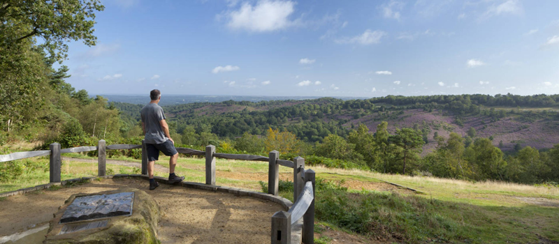
1. Go forward from the car park, past the noticeboard and the Surrey Hills pole, to the famous viewpoint over the Punch Bowl. Turn left here along a wide level path, passing a group of mature pines. After about 700m with fine views, you reach a junction of tracks at Highcombe Edge near a prominent relay mast. Bear slightly right in the direction of the Highcombe Hike, shortly going through a wooden gate beside a cattle grid and a noticeboard. In 100m, just after a seat, fork right on a narrower path which gives better views of the Punch Bowl. 50m after you re-join the original track, fork right with the main track but immediately fork right again on a lesser path which leads to a seat and a memorial to the bequeathal of Highcombe Copse to the National Trust. Continue onwards to re-join the main track. In another 400m or so, you enter a wood with mature pines and reach a post with many arrows.
2. Turn sharp right at the post, almost doubling back, staying with the main track, and follow it downhill into the Punch Bowl. When, in 400m, you reach a post with blue arrows near the entrance to a pasture, turn sharp left on a bridleway. Punch Bowl Farm is on your right. In 100m, avoid the track on the right leading to the farmhouse and continue ahead. The path takes you over a wooden bridge across the stream and then uphill between banks. At the top, go through a wooden gate to a junction with two paths ahead.
3. Take the wide path on your left. The path begins level and later rises a little. In about 350m the path loops completely round to the right before a fence, still going gradually uphill, and soon runs close to the fence. In 250m, the path veers right, away from the fence, and immediately meets a wide crossing track by a yellow arrow on a stump. Go straight over the track onto a narrow sandy stony path opposite. After 300m or so, you pass a clump of pines on your right, with an opportunity to look down on the terrain you covered earlier. You may see some Highland cattle that roam these hills and woods. They are gentle animals, despite their forbidding horns. After the pines, keep to the path as it curves left and right again, passing the corner of a fence. Now take a narrow gently rising path straight ahead across the open hillside, going over a descending crossing path. Your path runs inside the upper rim of the Punch Bowl with terrific open views on your right. In just over 300m it finally comes up to a T-junction with a wide sandy track. Turn right on this track.
4. In only 100m, on the right, just past a second line of stumps, you come to a sign pedestrian path. Fork right at this sign onto a much narrower path. This path leads up to a high spot – the highest in the Punch Bowl – where you have views in all directions, including for the first time south and east. Continue in the same direction, now steeply down and soon bear left to go right through a wooden gate next to a cattle grid and down to a surfaced trail, the old Portsmouth Road. Cross it to a track diagonally opposite.
5. The track runs parallel to the trail at first. Then it veers away and joins a pleasant metalled ‘quiet lane’. Note that you are on the Greensand Way, indicated by occasional ‘GW’ signs, a national trail running from Haslemere to near the coast in Kent. The lane levels out and rises again, very gently. After about 700m, it meets a green metal barrier at a junction on the left. (The path on the left leads to a viewing area for the Hindhead Tunnel project, once of much greater interest when it was being constructed. Turn left after about 300m to reach the viewpoint. Return the same way.) Fork left on a path past the barrier, passing two concrete blocks. In just 30m, by a post with arrows, fork right uphill to reach Gibbet Hill. On your right is the Celtic Cross and ahead are a sloping information board and a triangulation pillar marking various sights visible from this hill.
6. Turn right at the triangulation pillar, going past a post with a ‘GW’ arrow. At a large wooden gate, keep straight on, ignoring a right fork (which leads directly to the car park). You pass another ‘GW’ arrow and a green one bar metal barrier. Go straight over a junction by a small fingerpost, ignoring the right fork marked café. You come through a gate beside a cattle grid, still keeping straight ahead. In 70m, at a post with arrows, fork right, following another blue ‘GW’ arrow. You reach a junction at a curve in a major track with a seat and various minor tracks leading off. Avoid the first track on the right and veer right to join the wide sandy track that goes up into the open, still on the GW. Stay on this wide track, avoiding all side turns, however tempting. Finally, go through a gate, past some maintenance sheds, to the road. A little further on the left is the Devil’s Punchbowl Hotel and pub. Across the road is the café and the car park where the walk began.
DISTANCE: 4½ miles
MAP: OS Explorer 133 (Haslemere)
START: The walk begins at the National Trust Punch Bowl car park (postcode GU26 6AB).


