
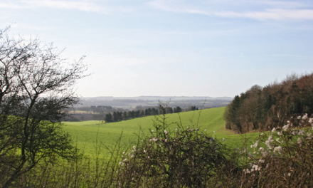
Quintessential rolling English countryside, following a river course with lakes, wetlands and wildflower grassland to an ancient woodland.
This walk leads you on a very pleasant circuit through typical Sussex countryside, with part of it following the River Lod running south from Mill Pond. This waterbody and the river valley contain many interesting habitats, ranging from wet woodland to reed swamp and wildflower-rich grassland. Mill Pond is reputedly one of the best sites in the county for breeding and wintering waterfowl, with birds including Kingfishers, Yellow Wagtails and Lapwing having been recorded. Diverse river valley grassland fields support the scarce plant Sneezewort and other attractive flowers including Betony, Devil’s-bit Scabious and Tormentil.
Lord’s Wood is a managed ancient woodland with diverse plant, insect and bird interest, particularly in the open ride under the electricity pylon line where you may see Orange- Tip and Speckled Wood butterflies in the spring and the Brown Argus butterfly and migrant Silver-Y moths in the summer. Lastly, if you look closely at Lurgashall’s cricket green, you can find sweetsmelling patches of Chamomile growing amongst the short turf in summer, or rare and colourful species of Waxcap fungi in the autumn months.
1. Head south along the lane from the village green as far as the stile and public footpath that takes you down through fields to the large lake of Mill Pond, and then over the dam bridge to Lurgashall Mill Farm.
2. A public footpath runs southwards from here, following the course of the River Lod to cross over another dam bridge at the lake at River Park Farm.
3. Continue on the footpath southwards through farm fields to Lord’s Wood, where you can choose to explore Lord’s Wood along the footpath before doubling back to walk northwards along
the eastern wood edge up to a farm lane.
4. Continue north along the footpath to pick up the farm track and bridleway north-eastwards back to Mill Farm, from where you follow your original route back to Lurgashall.

DISTANCE: 3.7 miles
OS MAP: Explorer 133
GRID REF: SU936271
PARKING: Park considerately around the village green
GETTING THERE: Start at Lurgashall village green, located 2 km west of the A283 Petworth-Milford main road at the end of Blind Lane.
FACILITIES: Lurgashall Village Stores – shop and post office.
Lurgashall Winery – local fruit liqueurs, honey meads and country wines, plus tea room, 1 km to west at Dial Green. GU28 9HA. 01428 707292
Noahs Ark pub, Lurgashall.
This walk is taken from the The West Weald Landscape Project, which is a Sussex Wildlife Trust project. For more information, please visit www.westweald.org.uk.
Neither the publisher nor the author can accept any responsibility for any changes, errors or omissions in this route. Diversion orders can be made and permissions withdrawn at any time. Where applicable, OS maps are used under the following licence: ©Crown copyright 2018 Ordnance Survey. Media 017/18.
Image: Lurgashall Mill © Copyright Keith Edkins


