Box Hill Stepping Stones
1. From the visitor centre at the top of Box Hill, follow the surfaced path away from the visitor centre. Ignore the track going off to your right and continue along the surfaced path running parallel to the road and you’ll see the view opening out in front of you.
2. Once you’ve admired the view from Salomon’s Memorial, walk down the sloped path which runs below the viewpoint. Take a right and continue along this path.
3. You’ll see some steps cut into the ground on your left; follow these downhill through the Yew woods. There are 275 steps to the bottom – take care as they can be slippery sometimes. Continue along this path; on the left you’ll catch glimpses of the river Mole.
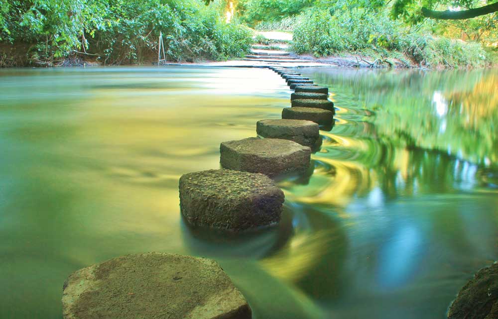
4. Continue downhill. As the path flattens you’ll reach a fork in the path. Take the left fork signed to the Stepping Stones. The River Mole and Stepping Stones are in front of you. You have a choice here. Either take a right at the rivers’ edge and follow the riverside path (you can cross the river at the bridge a little further along), or cross the Stepping Stones and follow the path running parallel to the river on the other side.
5. Once you’ve reached the footbridge, go through the gate next to it. This brings you out into a large open space. This is called Burford Meadow. Continue through the meadow. On the opposite bank of the river there are wooded chalk cliffs. These are known as the Whites.
6. At the far end of Burford Meadow there will be a road bridge in front of you. Follow the path upwards, just to the left of the bridge and you’ll come out on the pavement next to the A24. Take a right and cross the river and walk past the hotel on your right hand side. Continue along the pavement.
7. Take the right hand path immediately after the hotel. At the fork, take the left hand grassy track and continue heading directly uphill.
8. Join the wide grassy path on the ridge of the hill. The grassy slope becomes a white chalk path, follow it uphill.
9. Take the pathway on your left. As it joins the stony path, take a right and continue as it heads uphill.
10. You’ll pass an old building on your right. This is Box Hill Fort. You can walk all around the outside but not inside as there are bats living in it. Continue up the stony track and turn right at the road to return to the visitor centre.

DISTANCE: 2 miles
OS MAPS: Explorer 146, Landranger 187
STARTING POINT: National Trust Visitor Centre, The Old Fort, Box Hill Road, Tadworth, Surrey KT20 7LB
Summer Star Gazing walk at Black Down
1. From the car park on Tennyson’s Lane at point 1, take the main stone surfaced track out onto Black Down (there is a second car park further up this track). Head up on the main track and through the gate, past a notice board. Continue up the track, through a gully and past a bench with day time views over the weald to the east.
2. Continue along the main path, ignoring paths to your left and right, and past some small ponds on your right at point 2. Away from the light pollution of nearby towns, Black Downs sweeping skies and unspoilt views make it an ideal spot for observing the stars.
Try and spot the Milky Way, a ribbon of millions of stars, threading its way across the night sky. The light you see from a twinkling star has travelled across the universe for millions of years to reach you; so when looking at a star, you are actually looking back in time. Black Down’s prominent position in the landscape has also been used for much more over the years. A site on the hill was a key link in the chain of beacons that were designed to carry news of impending invasion to London. In daylight there are extensive views to the north here.
3. Carry on along main path to a small grassy triangle with a birch tree, then turn left and follow this path to a bench at point 3. This is a particularly good point for star gazing, with views to the west over the Milland Bowl and beyond to the South Downs. Also listen out for nightjars here, churring on the open heath.
The North Star, also known as the Pole Star or Polaris, is a very bright star and is always fixed above the north point of the horizon. It has been used for over 2,000 years to help navigators at sea and on land find their way. Until the end of grazing in the early 20th century Black Down was mostly open grazed heath. When the grazing animals left, trees began to grow and the wildlife disappeared. The heath is now being restored and grazed again and many species of wildlife are returning.
4. Head a further 65 feet (20m) or so along the main path and then turn left. Ignore the first turn to the left and then turn right at a crossroads to the Beech Hanger Woodland at point 4. Turn sharp left for the path back to the car park.
5. Take the main path back northwards towards the car park.

DISTANCE: 1.5 miles
OS MAPS: Explorer 133, Landranger 186
STARTING POINT: Tennyson’s Lane car park, GU27 3BJ. Grid ref: SU921308


