
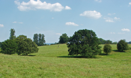
After the construction of the Hindhead Tunnel, the old winding Portsmouth Road was returned to nature and is now a glorious scenic walk where you can breathe the air of the moorland far away from traffic, with huge open views. The route is simple, making this a sociable walk with time to chat (or meditate) without the risk of going astray. There are no nettles on this walk so shorts are wearable. There is one potentially muddy section just after Highfield Farm so, except in a dry summer, you will find boots a blessing. Your dog can also come on this adventure. For full maps and more details, visit www.fancyfreewalks.org.
1. From the back of the car park, go to the famous viewpoint over the Punch Bowl to take in some of the landscape that will soon be under your feet. Turn right in the direction of the Sailor’s Stroll walk. Immediately keep straight ahead, avoiding a left fork with a wooden gate. In 150m, you meet a very wide crossing track with a slanting information board explaining about the old main Portsmouth Road that used to come through here before the tunnel was built. Turn left on this generous sandy/grassy path.
So many of us still remember the scenic traffic jams as lorries, cars and buses ground their way round the curves on this road, and the congestion coming from the southwest on the long crawl up to Hindhead. What a difference! There is no trace of the old road surface – in fact it is no longer level but takes on the natural contour of the hillside. It is certainly hard to imagine two lines of traffic speeding along this road. The Hindhead tunnel was opened in 2011 and this re-landscaping began shortly afterwards.
The path bends left, all the time with terrific views to your left. The relay mast on the other side will be on your return stretch.
2. After a pleasant 1¼ km, you see a small plantation of trees across the route and your path winds through them, now on a narrower course. In 100m or so, you come to a T-junction where a track comes down from your right. Go left and, in 20m, go right, joining a surfaced drive. In 200m, a tarmac bridleway joins you from the left. From this point, stay on this tarmac drive, ignoring a crossing byway and ignoring a footpath shortly after on your right. After ½ km on this easy surface you pass a milestone showing that you are half way between Liphook and Godalming, whilst the roar of the new Portsmouth Road gets more and more obvious. In a further ½ km you come through a gate with the narrow Boundless Road on your right and the A3 road itself just beyond. Keep left, into the National Trust Punch Bowl Lane car park.
3. With the main A3 road on your right, go to the end of the car park and turn left at a fingerpost on a dirt drive uphill, marked as a byway and with the reassuring sign ‘Café 2 miles’ (although this walk will take a more roundabout route). You come through a large wooden gate to avoid a cattle grid and pass a weedy pond on your left. Note the small flecks of tarmac along these paths, indicating their importance in past decades. 300m from the road, you reach a fork with red arrows. Take the right fork, going past (or over) another cattle grid. Your track curves right and leads down to a wide sunken track under banks of tall beeches. Veer right on this track, passing a bucolic landscape on your left. You pass a house and quickly arrive at the hamlet of Highfield with a junction and a 4-way fingerpost.
4. Turn left on a tarmac drive and, by a house, keep right steeply down a slope. (Riders often turn left and sharp right up a narrow path rather than risk the slope, as you can too.) The route is now a dirt track which may be muddy in winter. It curves left to reach a ford over a stream bed in an area rich with ferny fronds and tree roots. Ignore a footpath on the right and use the footbridge to stay dry shod. Your track resumes uphill, soon more steeply, climbing out of the gulch and passing meadows and gardens, becoming a surfaced drive. You meet a tarmac lane at a bend. Ignore a bridleway on your left and the lane on your right and keep straight on, joining the lane ahead. (The grassy path up a slope just to its right is private and not an alternative footway.)
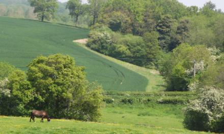
5. The lane soon curves right past the picturesque Upper Ridgeway Farm and its reedy pond. Stay on this quiet lane all the time, avoiding tracks on your right and avoiding a bridleway on your left as the lane bends right. You pass Glenhead on your left then the paddocks of Hyde Hill Farm and, on your right, the fabulous timbered Hyde Farm House which is Grade-II listed. On your right is a long green valley which must be horse heaven. The lane suddenly takes a right hairpin. Leave the lane here by turning left at a small fingerpost, just after the entrance driveway of Woodlands.
6. The path runs straight into the deep forest. Soon the area on your right is more open, due to restoration of the ancient lowland heath. (An info board soon tells the story of the Countryside Restoration Trust.) Later, ignore swing-gates on your left and stay on the main path at all times. After 800m on this path, you reach a multiple junction in a clearing with a marker post. Ignore paths ahead and to your right and instead keep well over to the left of the marker post, on a path which runs close to the sloping pine forest on your left. Soon you are in a V-shaped valley with pine slopes on both sides. Follow this austere lonely path, keeping straight ahead at a marker post after 300m. If there is a choice of paths it makes no difference because the valley confines you. After a dense patch of rhododendrons, you are joined by overhead wires. The path now climbs out of the forest and curves left as it comes up to meet a fingerpost and a surfaced driveway.
7. Turn right on the drive. You reach a major junction of tracks at Highcombe Edge under the big relay tower, with a small car parking area on your left. Avoid a semi-tarmac drive straight ahead and instead veer left on a wide level dirt track leading through woods. Soon there is a bench on your right with fine views into the Punch Bowl. Keep straight on at a fingerpost, soon reaching the viewpoint and parking area where the walk began.
DISTANCE: 6 miles
OS MAPS: Explorer 133 (Haslemere)
STARTING POINT: The walk begins at the National Trust Punch Bowl car park, GU26 6AB. Charges apply for non-NT members.


