
Alice Holt is such an ancient forest that no one is completely certain how it got its name. Most likely, it came from Ælfsige, anglo-saxon bishop of Winchester and “holt” meaning simply “a wood”. The Forestry Commission took it over in 1924 and established a research centre which advises on forest management, nursery, soils etc. anywhere in the country and does extensive research here. They also re-established an arboretum (close by, though not on this walk), with the help of an army of volunteers. There is always lots going on and lots to do at Alice Holt, so it is well worth a trip for visitors of all ages. For more information, please visit www.forestry.gov.uk/aliceholt. This walk is taken from www.fancyfreewalks.org and reproduced with kind permission.
1. From the car park, go ahead past a metal barrier and follow the wide stony path. After 200m, ignore paths left and right. (The right-hand path leads to a picnic area and a circular path. The left-hand path leads to the Alice Holt Research Centre.) After another 400m, go straight over a tarmac path. The path curves left with great views to your right over Hampshire. Just after, avoid side tracks left and right. The path descends between cypress trees, then ascends again and runs level amongst pines, becoming more grassy. After Alice Holt Forest and another level section, a total of 2 km from the car park, you come to a more open area with a wire fence ahead on your left, next to a tree plantation.
2. Avoid the path that forks left to a tall gate but, 20m further, turn right on a path. (If you are adventurous, and want to stay dry, you can instead continue on the main path for 120m and find a very narrow but clear path, almost hidden, on the right – beware of an extremely narrow one just before it – and follow it through dense conifers, wheeling left a bit at the end through some tall pines . This takes you to the Y-junction mentioned below.) After nearly 300m on this straight path, at a junction, turn sharp left to arrive in about 200m at a Y-junction. Take the right fork on a path that takes you through a wooden barrier. Keep straight ahead with houses and gardens on your right and, after 130m, turn right on a quiet residential road. In about 250m, just after St Huberts (with its little turret and wind vane) turn left on a narrow footpath. This takes you past a filling station (with a small shop) to the main A325 road.
3. Cross the road carefully and turn right to reach, at a junction, the Halfway House pub at Bucks Horn Oak, sadly closed and for sale at the time of writing. Fork left by the pub on a side road signed to Dockenfield. In 100m, ignore a muddy byway on your left, continue a further 150m and turn left onto the tarmac drive which is the entrance to Alice Holt Forest. Avoid a left fork that only goes to the office and stay on the snaking drive, passing a car park on your right and forking right to the café, toilets and cycle hire centre.
4. Instead of looking for the shortest way, this section takes you in a loop round the best part of the forest, but always finding dry paths. From near the café, toilets and cycle hire, turn right downhill on a path marked as the Willows Green Trail. Your path goes over a bridge with railings. At a T-junction,turn left on the Long Route, soon reaching a T-junction with a wide sandy gravel track. Turn right here. In 200m, at a crossing path with waymarkers, turn left on the red route, a grey gravel path, passing several stick huts or ‘dens’ as your path veers right. After 200m on this path, at a T-junction, turn left on another wide path, with houses sometimes visible beyond. Keep ahead on this path for about 350m, avoiding a left fork halfway along, until you reach a major T-junction, indicated by a fork in the path. Keep left here and turn left as you join another path at the T-junction,still on the red route.
5. You will be following this path more or less straight for over 600m. In about 100m, avoid a left fork at a marker post, thus leaving the red route. Your excellent wide path snakes its way downhill. In a dip, you pass a junction sharp left and, 50m later, reach a crossing path. Turn right on the crossing path (the path left would take you back to the Centre). You will be following this main, rather curvy, path for over 700m. Your path wheels left and goes over a crossing path. Your next encounter is with that rather muddy byeway across your path. Your path curves right as it meets a grassy path on the left and goes over a stream. Stay on the main path as it bends sharp left and then right again, avoiding all the lesser, muddy side paths.
6. On your left soon is George’s Lonely Oak, named after a long-serving forester. You soon reach another junction. Turn left here to avoid the muddy horse path ahead and quickly right again, staying on the wide dry path, passing some cypresses and a picnic table. This takes you, in another 100m or so, to a very wide path at an oblique T-junction. Turn right on this wide path to reach, in 150m, a 5-way junction.
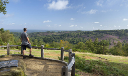
7. Now leave the main route, which bends left, by going straight ahead on another wide path. In about 200m, you reach the border of the forest indicated by a wooden gate and a small car park. A small community on the Surrey border, welcome to Rowledge! St James’s church is on your left. Keep straight ahead on the lane to a junction in the village.
8. Turn left on School Road, passing the Cherry Tree pub on your right, a worthy watering hole with two gardens and some good food. Continue on the road, passing various houses, a recreation ground and a parking area. Rowledge House, soon on the right with the dragon-crested outhouse, was a hostel during World War II for Jewish child refugees who arrived on the Kindertransport. At a T-junction, turn left on Fullers Road. Avoid a footpath immediately on the right, continue on the road for 250m and, just past Fox Hollow, turn right at a fingerpost on a footpath.
9. This path, which is almost dry, soon takes you over a gurgling stream, through woodland and out to a junction of farm tracks. Keep straight ahead and, after passing an entrance to a farm, keep ahead on a hard-core grassy track [March 2014: it was partially blocked by a heap of rubble – hopefully clear now!]. Finally, you reach the main A325 road. Cross the road carefully and go through a swing gate directly opposite into the front yard of the Forest Inn, Holt Pound, a family pub and a reliable place for last-chance refreshment.
10. Pass the pub on your left and go through a wooden gate into a meadow by a four-way fingerpost. Fork left here across the grass, aiming for a metal swing gate in front of a house visible in the trees ahead. Go through the gate, turn right in front on the house and go past a wooden barrier back into the forest, avoiding side paths. This long straight (and fairly dry) path makes for a pleasant final saunter back to your starting point. After pines, a more open section, and more pines and birch, you go over a crossing path with views on the right. Finally, after a total of just over 1 km on this path, you go through a metal barrier to a lane. Turn left on the lane and in 20m fork right, back to the car park where the walk began.

DISTANCE: 7 miles
OS MAPS: Explorer 145 (Guildford)
STARTING POINT: Gravel Hill Road car park. The nearest postcode is GU10 4LJ but for navigation purposes, you need to set GU10 5JD which will take you on the Gravel Hill Road.
GETTING THERE: you reach the car park from the A31 road (signposted Winchester Alton), just 3 miles (5 km) west of Farnham, Surrey. If coming from the east, go straight ahead at a roundabout, ignore several left turns until you cross the Hamsphire border; just after you glimpse the Bull Inn on the right, take a left filter and turn left, in front of a clump of pines on narrow Gravel Hill Road. Follow this fabulously twisty road for just under a mile, entering the dense forest and going over a railway. The car park is ¼ mile after the railway bridge, the first obvious right fork on a gravel, rather uneven, track. Park at the end or tight along the edge if full.


