This walk has an almost six mile initial section which has in it a strenuous climb but it will reward you with some spectacular views. The second section is much shorter and more or less flat. The description was submitted by Guildford Rambling Club who will be walking it in May (see guildfordramblingclub.org.uk). You are welcome to walk it with them.
1. Cross the bridge and, on the other side, take the footpath to the left. After a level start, climb a little to a T-junction with a lane. Turn left and the lane quickly ends and continues as a track. After 250 yards fork right on a red arrow permissive path. Follow this through, ignoring lefts and rights, to a road. Go straight across to continue forward along a track for about 1/3 mile to a T-junction. Here take the red arrow option left. Now walk ¼ mile to a busy road. Turn right and walk uphill along the road for 300 yards to find a footpath left, at the side of the entrance to Keepers Cottage Stud. Follow this as it rises to pass Yew Tree Cottage and then the two Waverley Cottages and reaches another road.
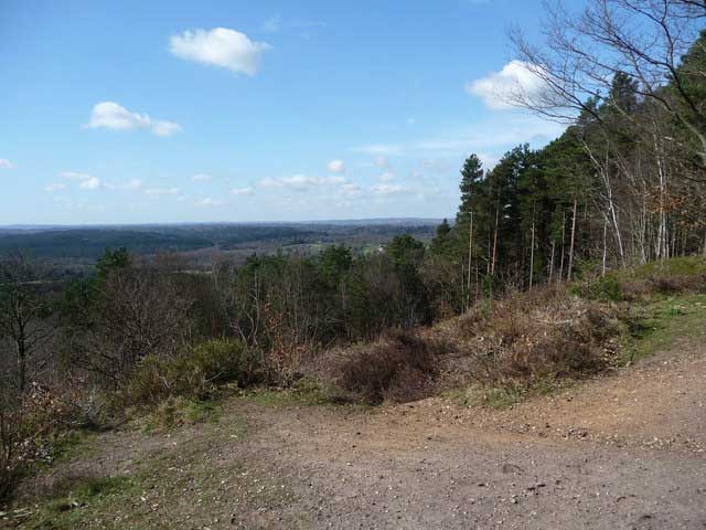
2. Go straight across to join a bridleway and follow it left and then left again. Walk through to Crooksbury Hill car park. Now take the leftmost option from the back of the car park to start the long and increasingly steep climb up onto Crooksbury Hill. Stop at the viewpoint. It will have been worth the effort! Afterwards, with your back to the view, head right, off of the other side of the top and steeply down. Trend a little left to reach a point where a path strikes off right and runs alongside a fence. Follow this through to reach a road directly opposite the start of footpath along a wide track. Follow this for about 1/3 mile to a T-junction with a wide track. Turn right and walk out into the Crooksbury Conservation Area. Now walk for about 3/4 mile along the wide track, at one point passing out of the conservation area then passing a few houses and eventually reaching a road.
3. The Donkey PH is on the other side of this road but you will not reach it because, some 30 yards before the road, at a 3-way signpost, is a footpath left. Take this and climb up to emerge at the end of a drive. Continue forward to exit through the gate of Three Barrows (adorned with eagles) onto Seale Road. Go straight over and along the path opposite to reach another road. Again go straight over, heading towards Broomfield Cottage but then turning left onto a footpath in a field. Cross the field half-right to a gate into a wood. Walk through the wood to reach the road that runs through the village of Gatwick. Turn right, cross a stream and continue for about ¼ mile, passing the houses and going over a rise and then turning right into Attleford Lane. Some 350 yards along here, by the side of a house, take a footpath right. Pass a house and farm buildings and the track becomes a narrow path. Traverse a footbridge eventually arrive at road. Head right. Cross a bridge over a river and, 100 yards further on, turn right on a track. Emerge in a long field. Continue to exit it at the far end. The path brings you to the dead-end of Ham Lane. Follow this, to the right, for some 1/3 mile, to reach its end at the main road through Elstead. Turn right and walk along to the Woolpack PH, a café, shops and a little green where you could picnic.
4. After lunch, take the Churt/Thursley Road and walk to the church. Here, turn right to walk along for about 1/2 mile to the end of Westbrook Hill. At the end of the road, take the track right, into an MOD area. Follow this wide track for 1/4 mile to reach a 5-way junction. Of the two blue arrow options ahead, take the rightmost. Continue on across heathland, passing a house on the right-hand side, still following blue arrows and ignoring lefts and rights. The track swings close to the river (which is down to the right-hand side). Reach a barrier and, beyond it the angling lake at Stockbridge. Continue forward to the road by the Stockbridge parking area and turn right to walk along inside the hedge to Tilford and the start.

DISTANCE: 9.5 miles
OS MAPS: Explorer 145 Guildford & Farnham, Godalming & Farnborough
STARTING POINT: The parking area by the bridge in Tilford, between the cricket pitch and the river.
REFRESHMENTS:
The Woolpack PH, The Green, Elstead GU8 6HD
T: 01252 703106
www.woolpackelstead.co.uk
The Barley Mow, Tilford GU10 2BU
T: 01252 792205
www.thebarleymowtilford.com
Map © Crown copyright 2016 Ordnance Survey. Media 008/16


