
At Hikes of Surrey, we begin most of our walks from St Martins Church because of the easy parking and the spire acts as an excellent focal point and marker when we’re out in the hills. Parking is easiest in St Martins car park just north of the church. Make sure you park in the correct area as there are separate short and long term parking spots. If you would like a guided walk along this route, or to find out about many more, please visit www.hikesofsurrey.com.
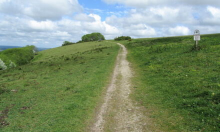
1. Leaving the church, walk west down Church St until you come to Station Rd. Turn right. Walk up the road keeping on the right side. When you come to Ashcombe Rd, go straight across to Yew Tree Rd. Keep walking up the hill until you come to the footpath. Keep heading north on the footpath. Stay to the left walking down hill. Welcome to Denbies Winery, England’s largest vineyard! Cross through the kissing gate and head up the hill. You will see Box Hill on your right. When you come to the gravel road, head slight left to stay on the footpath. You will go down and then uphill again. When you come to the paved land-train track, cross over it and continue along the treeline until you come to the corner. Note the bat houses on the left. At the corner of the vineyard, go through the kissing gate, but not before taking one last look at this breathtaking landscape.
2. You will be standing on the North Downs Way (NDW). If you were to turn left you would end up in Farnham (24 miles), Turn right and you could walk all the way to Canterbury and/or Dover. But we will leave that walk for another time. Cross the NDW and continue north on the footpath. The footpath turns into a drive, keep straight until the paved drive turns right. Keep straight and cross over the stile. Follow the footpath through the field as it bends to the left. This pasture offers views of Box Hill, Norbury, Westhumble, and hills surrounding Mickleham that most locals have never seen. Take some time to soak up the unique perspective that this simple field has to offer. Cross over the stile and continue along the footpath. Take your time; this footpath is narrow, uneven and has a barbed wire fence running along the right hand side. Cross over the stile and follow the footpath through the field as it curves to the right. Cross over the stile.
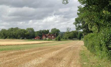
3. You are now standing on Ranmore Common Rd. Turn right and head north to Chapel Ln. Be mindful of cyclists; they can come quite quickly from behind you. Turn left. Walk along the road. Pass Bagden Farm. Before the road turns, go through the footpath gate at the cottage. Keep straight along the wide footpath. You are now in the Polesden Lacey Estate. This footpath takes you slightly uphill and then turn to the right. You will pass the estate’s charcoal burning area on the right. Follow the footpath as it turns left and crosses the bridge. Keep straight and go through the gate. On the left there is a clearing that offers great views of the valley and the Tanners Hatch youth hostel. Continue up the footpath until you come to the folly made of columns on the left. Although at this point you are free to explore the grounds as you see fit, we enjoy walking through the columns along the wide walk as we feel as though we are romantically taking the air as one did in the late 19th century.
Take your time to explore one of our favorite National Trust properties; there is plenty to see and do at Polesden Lacey. Members free, otherwise charges apply.
4. After you have finished having a look around, leave the property through the main entrance and turn left along the car park. Go through the gate and walk south along the paved path. Continue downhill and pass under a beautiful thatched bridge. At the crossroads, keep going straight ahead towards Yewtree Farm. Coming up the hill, turn slight right. At Yewtree Farm Keep to the left. Shortly thereafter, keep to the left again. I will stop here to say that there are many unmarked, or at least not well marked, footpaths through this area. If you find yourself off of the route described here, don’t fret, simply continue to head south until you come to Ranmore Common Rd and head to the National Trust car park at Ranmore Common/Denbies Hillside. Back to the route: Keep straight on this footpath. You will cross two distinct perpendicular footpaths. Keep going until you come to Ranmore Common Road. Cross the road, walk to the car park and go through the gate to Ranmore Common/Denbies Hillside.
5. Walk south stopping at the corner of the property to enjoy the incredible view. Turn left and head east along the footpath. Walk through two gates. The footpath will make a hairpin turn to the right down a steep chalk path. Continue until you come to the Pilgrims Way Trackway, turn left. Follow the trackway all the way down to where it dead ends into a home. However, make sure you stop to take in the sweeping views of the Greensand Valley along the way. Turn right and follow the path through the woods. Keep heading east. You will come out at Ranmore Rd. Turn right and follow the road to Station Rd and turn right again. You will come back to Church St., take a left and then you will be back where you started.

DISTANCE: 8 miles
MAP: OS Explorer 146 Dorking, Box Hill & Reigate
START: St Martins Church, Church St, Dorking RH4 1DW


