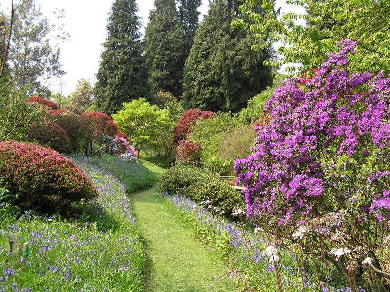
Here is a peaceful rural ramble through the meadows and woodlands of southwest Surrey. It starts in Chiddingfold, one of Surrey’s most picturesque villages which offers good chances for a rest and refreshment. Near the end, it takes you through some spectacular wooded terrain. There are no ploughed fields along the way and only a few sheep for companionship. In late spring, many of the paths are fringed with bluebells. Dog friendly but lead needed! Midway through the walk you go close to Ramster Gardens. This walk is taken from www.fancyfreewalks.org with kind permission.
1. Go along the side of the Green towards the church and the Crown Inn. Just before the inn, go left through a passage, re-joining the road by a butcher’s shop and continuing past the Swan Inn, crossing a bridge over the Anstead Brook and ignoring a side road. At a fingerpost after the last house, turn left on a footpath. This narrow path runs between fences, by a field, over a stile and along the right-hand side of a meadow. At a post with a yellow marker go right up some steps and left beside a wire fence. This leads you over a stile, uphill through a bluebell wood and over a stile into a sheep meadow. Turn left along the edge of the meadow.
2. Go over a stile in the corner onto a woodland path in the Highbeech Plantation. Go carefully down the slope ahead, aided by steps, and past a pond on your right. The path takes you over a stream, up and along a grassy path by a fence and a large pasture. The path elbows left by a gate and finally bends right to go over a stile. Turn left on the grass beside the driveway coming from Old Pickhurst and, at a T-junction, turn right on a road, immediately avoiding a road junction on your left.
3. After 150m, go left over a stile into a small green meadow and, in less than 100m, go right over a small bridge and stile into a sheep pasture. Cross the pasture aiming for the right-hand edge of a line of trees on the other side. Once there, go over a stile beside a metal gate and continue uphill next to a fence on your right. In the far corner, which can be a little swampy, go over a stile and cross the centre of the next rough meadow, aiming for a large house visible ahead, adjoining some long buildings (actually racing stables). Go over a stile to a road and turn left on it, passing Fisher Lane Farmhouse.
4. After only 40m, go right on a rather narrow overgrown path which comes out by the racing stables, zigzagging right-left as it does so. Cross over a horse exercise path and continue up a wide cinder track. The track curves right and bends left again. You have an expanse of grass incorporating a large circular horse exerciser to your right and a line of trees ahead. Leave the track as it curves away and aim straight for the line of trees to go through a small gap in the hedgerow to a 3-way fingerpost. Turn right beside the hedge and, in 100m, on meeting a track, turn right and immediately left along the left-hand edge of the grassy expanse. In 15m, ignore the first yellow arrow on your left and continue to the far corner.
5. In the corner, go over a wooden bridge and take a path straight ahead, gently uphill through a bluebell wood, Surrey Copse, in the direction of the yellow arrow, soon crossing under wires. At the top, veer left at a yellow arrow immediately reaching a fingerpost. Ignoring a stile straight ahead, turn sharp right in the direction of the middle finger on a narrow path into the woods. The floor here is thick with bluebells in late spring. The path finally leads out into a small meadow. Veer left to a (broken) metal gate and turn right on a tarmac lane. In 70m, go left through a modern kissing-gate into a sloping meadow.
6. Go straight across the meadow, heading for a large wood on the other side. A large metal gate reveals itself as you cross. Go through the gate into the woods of Griggs Bottom and immediately turn left at a fingerpost. In 60m, at another fingerpost, your path veers right up deeper into the wood. In about 150m, the path emerges into a large sloping green field. Keep ahead along the right-hand side of the field. At the corner, go through a small wooden gate and turn left on a wide farm track. In 30m, follow a hairpin round to the right. In 200m, at a fingerpost, veer left towards the farm buildings. You pass a reedy pond and, on your right, Redlands Farmhouse, then Honeypot Cottage and the buildings of Gostrode Farm. Stay on the tarmac, ignoring a footpath on your right and a bridleway on your left at a bend. Finally you pass some houses, go over a grid (or through a small wooden gate), pass a footpath on your left, and progress onwards till you reach the main A283 Petworth Road by a Shell filling station (which serves snacks and drinks) in the hamlet of Ramsnest Common. You will be continuing by crossing the road and turning right.
7. Having crossed the road and turned right, go 150m along the footway and turn left on a side road, Killinghurst Lane. However, by continuing another 100m or so along the main road, you could make an excursion to Ramster Garden (see special offer), famous for its glorious spring colours. Follow quiet Killinghurst Lane, catching a glimpse of Ramster Garden on your right as you go. The lane dips to go over a stream, passing farm buildings and winds its way uphill. The lane zigzags through a broken wall and descends. You pass a meadow on your left with a beautiful cedar, belonging to historic Killinghurst House. Finally, the lane takes a left bend.
8. Leave the lane here by turning right at a fingerpost on a narrow path. The path runs along the right-hand side of a field and, in 40m, forks right into woods. You are in a long strip of woodland known as Hollis’s Hanger. It runs beside a stream gully down on your left. This primeval and exciting landscape will be yours to enjoy for 1km – and probably alone because few people come here. In late spring, this is a notable place for bluebells too. Eventually the path descends to the level of the stream and crosses it by an excellent bridge. After the bridge, keep left, following a thin stream on your left. You may need to hop around the mud in this section. Your path crosses the stream using a 3-plank bridge. At the top, you come to a T-junction with a much wider path. Turn right on this path.
9. The path runs past some corrugated farm sheds and onwards through woodland (testing your mud-hopping skills again). It eventually joins a tarmac driveway coming in on the left from Hollyhurst. This lane soon passes houses on both sides in the hamlet of Upper Sydenhurst. Keep straight on along this very quiet cul-de-sac lane passing several footpaths on the left. In 1km, the lane reaches the main road in Chiddingfold. Turn left and cross the road to the Crown Inn and the Green where the walk began.

DISTANCE: 7 miles (11km)
OS MAPS: Explorer 133 (Haslemere)
STARTING POINT: The walk begins at Chiddingfold, Surrey, postcode GU8 4TX. Park alongside the Green.
REFRESHMENTS:
The Crown, Chiddingfold T: 01428 682255
www.thecrownchiddingfold.com
The Swan,Chiddingfold T: 01428 684688
www.theswaninnchiddingfold.com
The Tearoom at Ramster T: 01428 654167
www.ramsterevents.com


