Weekend Walk: Lurgashall and Lickfold (5.5 miles)

This is a gentle walk through the open pastures and woodland of this lesser-known part of West Sussex. The centre point of this walk is one of the best gastropubs in West Sussex which charges Mayfair prices but will be happy to pull you a pint when you relax on their comfortable sofas. At the start and finish is a typical (and excellent) village pub by a cricket green. Provided by www.fancyfreewalks.org.

1. Starting in Lurgashall, go to the south side of the green where there is a red phone box and the village shop. Pass them on your left to reach a four-way junction by the aptly named Signpost Cottage. Fork left here in the direction of Village Hall, Mill Farm. 250m after passing the last house, as the lane curves left under great oaks, go right at a fingerpost, up steps and left along the left-hand side of a field, on a generous grassy verge. There are fine views right to Bexleyhill and its aerial. Your path goes under wires and comes through a gap in the hedge. Turn left here into another crop field which also has a good grassy border. In the next corner, turn right with the same field still on your right. Go through a gap into the next field and continue as before. In the next corner, go over a stile (which can be squeezed past) to a tarmac lane near a road junction.
2. Turn right on the lane to reach, on your right, the Mill Pond in 150m. The lane is a causeway across the side of the pond, going over a sluice, running between the buildings of Mill Farm. The farm specialises in rare pig breeds and you may see free-range piglets along the way. Continue ahead to a large metal gate by a 3-way fingerpost. Do not go through the metal gate but, immediately before it, turn right on a footpath and follow a wide sandy track across the field. The stone-lined surface suggests that you are on an old roadway.
3. When you reach the end of the field, bear right on a wide farmer’s path, avoiding a path beside the field on your left but, in just 20m, go left through a gap into a large field (care! some walkers go wrong here as ploughing may obscure the paths) and take a diagonal path across it. In the far corner, go through a gap and take a diagonal path across the next field (possibly a fainter path following a vehicle track). In the far corner, go down the grass and through a large metal gate into a luscious green space. Immediately turn right at a rather decrepit 4-way sign on a path through bushes, winding across an open area where springs erupt and where the best blackberries are to be found. Go up and over a stile and along the right-hand side of an attractive meadow, crossing under wires. Continue through a gap in the corner and similarly beside the next meadow, passing a tile-hung cottage on your right. Your path takes you over a stile, on a narrow path between fences and down steps to a road. Turn left on the road, immediately reaching the Lickfold Inn.
4. After a possible break, take the lane beside the pub, signposted Fernhurst, passing the old barns of Gentils Farm. The broad crest of Blackdown is in full view on your right. The road curves right and passes Lickfold House on your left. Just after the house, at a small fingerpost, go left on a wide grassy path running beside a lush meadow on your right. There is a small herd of noisy cattle corralled here in one of the fields but sometimes they may be in the field on this route, as when the author arrived, walking past them without any problems. But if you believe this might be a snag, simply stay on the lane, re-joining the walk after 750m at Hoewyck Farm. As you enter woodland, at a fingerpost, keep straight ahead, ignoring a left turn. The path crosses a deep stream and approaches a large old wooden gate. Go over a stile beside the gate and follow the right-hand side of a pasture. The edge curves left and reaches a large metal gate. Go through this gate (releasing a clasp on the chain) and continue similarly in the next pasture. Near the top right-hand corner, go right over a stile and go diagonally up the grass and through a large wooden gate, out to the lane.
5. Turn left on the lane, passing the old barn of Hoewyck Farm. Stay on the road as it bends right, ignoring a footpath on your left. Where the road bends left, leave it by turning right on a signposted bridleway. Continue through a (usually open) metal gate and follow the sandy path, gradually rising under hollies. After 300m on this path, go through a small wooden gate and, in 10m, go left through a large wooden gate into a sloping sheep pasture. (This tactic avoids the stile.) Go up the left-hand side of the pasture and veer right to cut the top left-hand corner. As you approach woodland, avoid a large wooden gate and go left over a stile just 10m after it.
6. Follow a clear path through Gentles Copse. The path goes over a 2-plank bridge and a stile into a large grassy meadow. Follow the left-hand edge and, after 300m, at a 4-way fingerpost, keep straight on, staying in the meadow. Shortly, go over a stile in the corner onto a woodland path. The path soon executes a right-left double bend and takes you over a 2-plank bridge with a rail. It meets a stony track with the gatehouse to the Black Down Park Estate on your left. Turn right on this track. The track comes out to a road. Your route is left on the road but first, just on your right, is a rather eccentric building.
7. Having turned left on the road, in 100m turn right on a rough tarmac lane. In 100m, opposite Guardian Cottage, turn right at a fingerpost into woodland. follow the path through bracken to a marker post where your path bends left. At a 3-way fingerpost, turn left. Your path emerges from the wood, across grass to a tarmac drive. Turn right on the drive and immediately left at a fingerpost on a woodland path and quickly bear left at another fingerpost. You meet the corner of a field by a bank, next to a stile, an old gate and a fence. Avoid the wide path straight ahead and instead go left over the bank and veer right on another good path.
8. Follow this woodland path for nearly 800m. On your left, the wood falls away quite steeply in places. Finally, you come through a swing-gate into an open meadow. Keep to the right-hand side of the first small meadow, leading to a small gate into another meadow. The spire of St Laurence Church is visible ahead. A swing-gate takes you into an orchard, followed by another swing-gate where your path veers a fraction left. You cannot help but notice, if you have a backpack, how tight these gates are! Two more swing gates, with an orchard in between, lead out to a tarmac lane. Turn left, leading immediately back to the village green where the walk began.
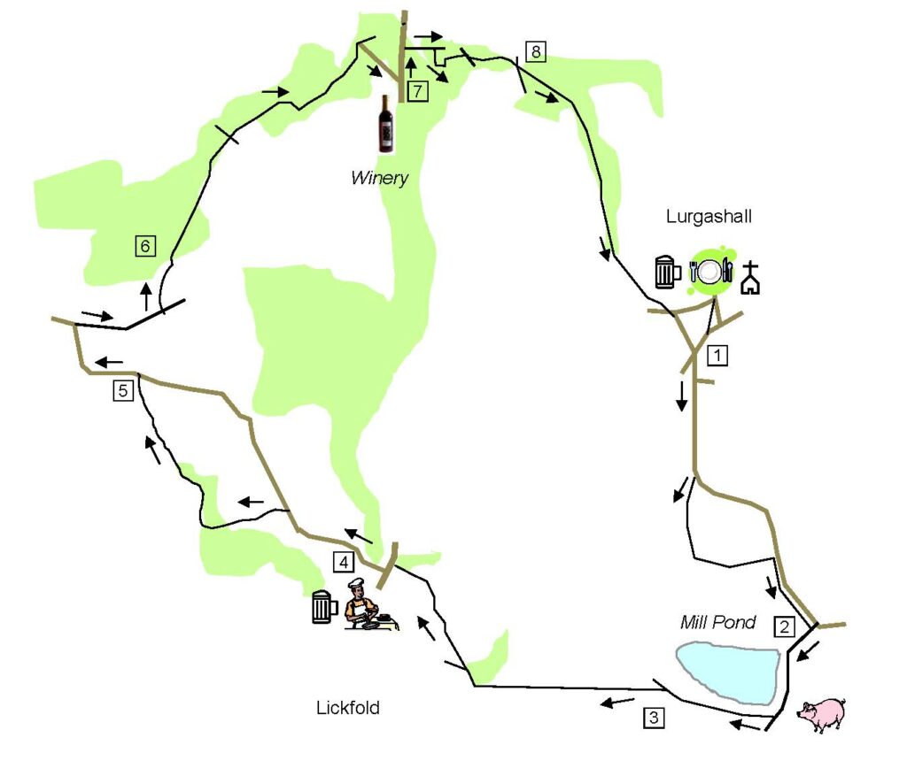
pages-from-lickfold

DISTANCE: 5½ miles

OS MAPS: Explorer 133 (Haslemere and Petersfield)

STARTING POINT: Lurgashall – car park or park in road

REFRESHMENTS:
Lickfold Inn 01789 532535
Noah’s Ark 01428 707346

Image: The Noah’s Ark, Lurgashall (www.westsussex.info)


Roast Pumpkin Hummus

Pumpkins are not just good for sweet recipes or soups. They can be used in chillis, curries, stews, quiches, pasta bakes and much more.
Try spicy oven baked pumpkin chips or add cubes to oven roasted vegetables to accompany your next roast.

Roast Pumpkin Hummus

Chop 250g of pumpkin and roast in a 180C oven for 25 minutes. Mix together with 400g can of rinsed and drained chickpeas, 2tbsp tahini, 1tbsp lemon juice, 1stp ground cumin, 1 crushed garlic clove, salt and pepper and blend together. Add 2 tbsp chopped fresh coriander and serve.


Planning for Care Fees in later life

One of the biggest challenges of the 21st century is Britain’s ageing population. Improvements in health, diet and preventative care mean we are living for longer. In 2012, the number of over 65’s in the UK surpassed 10 million for the first time.

The ‘oldest old’, which describes those aged 85 or over, has also risen sharply. During the 2011 Census, there were 1.25 million over 85’s in England and Wales, up by 30% from a decade earlier.

As a result of this ageing population, one in three women over age 65 will need residential care at some point in their lives. For those women who do not require residential care in later life, there is a 50% chance they will need some form of care at home.

These changing demographics have big implications for our care in later life.

At the same time as our population ages, funding for older people’s social care has stagnated. Public funding for later life care has been cut by 10% in real terms and local authorities have scaled back their funding for social care.

There has been a big increase in the number of older people using residential nursing homes, around 21% higher at 164,000 according to the most recent figures. The number of older people using nursing care has also risen, to around 79,000 people today.

With greater demand for care and less publicly available funding, the expensive cost of later-life care will often fall on individuals and families.

In the South East, the average cost of a residential care home is £669 a week. This rises to an average of £920 a week if nursing care is required. Those who prefer to receive care in their home in later life face average costs of £248 a week in Surrey, and they also need to meet the cost of utilities and maintenance for their property.

These are big numbers and can seem daunting for families who need to make important decisions about care packages for elderly relatives.

A means testing system is in place in England, which determines if any financial assistance is available from your local authority. This means test considers the income and capital assets of the person needing care. If you have assets or savings of less than £23,250, the local authority will help to pay for your care costs. You pay your own care costs if you have more than this.

The value of your home is often excluded from this means testing process; it will not be counted as capital if certain people, such as your husband or wife, still live in the property.

Recognising the financial and social challenges prompted by an ageing population, the government instigated a formal review of care funding, which was started by the Dilnot Commission in July 2010. This resulted in a new Care Act in 2014, which came into force last year, although some key aspects of the legislation have been deferred until 2020.

If the government decides it is affordable, we could see the introduction of a cap on how much you have to spend on your care needs. Once this cap reaches £72,000, the local authority will then pay for your eligible needs. The cap does however exclude daily living costs, such as food and accommodation in a care home, and critics have warned that once introduced the cap is likely to benefit few individuals.

When an elderly parent or relative needs care, either in a residential care home or within their own home, it can be a worrying and stressful time for their families. Understanding the various costs of care and any benefits available to help with these costs can quickly become a full time job.

There are some simple steps families can take before the need for care arises, to make things less stressful in the future.

Putting in place a lasting power of attorney is a must. These legal documents are a way of giving someone you trust the legal authority to make decisions on your behalf if you lack mental capacity at some time in the future. There are two types and both should be considered. One covers financial decisions and the other takes care of health or care decisions.

You can only set up a lasting power of attorney if you have the mental capacity to make decisions, so putting this in place early is important. The document must be registered with the Office of the Public Guardian before it can be used.

Another simple step to consider is discussing future care needs for elderly parents or relatives. The best prepared families will go as far as visiting residential care homes, making a choice before the need for care arises. This can put minds at rest when health does decline, with families safe in the knowledge that the choice of home was made jointly.

Care fees planning can be a complex area of financial advice, which is recognised by the requirement from the Financial Conduct Authority (FCA) for advisers to hold a specialist qualification. A handful of professional advisers who choose to work in this area of advice go a step further, completing the Later Life Adviser Accreditation.

This accreditation from the Society of Later Life Advisers (SOLLA) is the recognised benchmark for advice skills of those advisers who specialise in the older client market. It represents a real endorsement of their skills and experience in working with, and understanding the needs of, older people and their families and carers.

With an ageing population and many older people living with dementia, there is a good chance you or someone close to you will need to address later-life care planning at some stage in your life. Making good decisions based on a full understanding of the various costs, rules and benefits is easily achieved by working with an experienced independent financial adviser.

Martin Bamford is a Chartered Financial Planner, Chartered Wealth Manager and Accredited Later Life Adviser. He is managing director of Informed Choice, an award-winning firm of Chartered Financial Planners based in Cranleigh, Surrey.


Weekend Walk: Chawton to Bentworth (10 miles)

This walk starts and ends in Chawton, well worth a visit in its own right and the home of Jane Austen. Her house is opposite the village car park. The walk description is provided by Guildford Rambling Club, see guildfordramblingclub.org.uk.

1. Walk back to the A31 roundabout and cross into the road opposite. Go under a bridge (the Watercress Line) and, a little way beyond it, turn left along a lane, Chawton Park Road/National Cycle Route 23. You will now walk more or less straight ahead for almost 2 miles before you turn off. Along the way, you will initially pass a few houses and then the lane becomes a track. You pass a Chawton Farm information plaque and go through various gates and along a wide grassy avenue through Chawton Park Wood. You ignore various lefts and rights including one very wide track sweeping away left. Shortly after the latter you encounter a fork and take the right-hand branch. Soon after that you turn off, taking the second clear but unsigned path heading away to the right and up through trees.

2. At the top, you reach a fence and walk left looking for a turning off to the right (which may or may not now have a signpost). Here, take this turn right to continue forward, passing a barrier and proceeding along a path which soon merges into a wide vehicle track. Follow this for over half a mile, passing metal gates and barriers, until reaching a small house (on the left-hand side). Here, take a bridleway right and follow the track until you reach houses and a road. Turn right along the road but immediately take an unsigned path off right, over grass near a house and along a fenced corridor to reach a field. Walk along the left-hand side of this field and the right-hand side of the next to reach a tarmac drive. Go straight across and along the left-hand side of the next field. Keep going forward until reaching a hedge and dropping down through a gap in it onto a wide stony track (Turners Lane). Turn left and walk up into Bentworth, emerging on a road with the Star Inn to your right. At April 2016 the pub was ‘closed until further notice’. This may or may not be still the case when you do the walk. Fear not though. If it is closed you could use the benches opposite for your picnic. And there is another picnic option and another pub a little way further on.

3. Follow the sign to the school and church and then turn right to walk past the school and straight through the churchyard (a possible picnic spot). The path exits the back of the churchyard and continues to meet a road. Go straight across and into a side road signed to Shalden and Alton. Follow this road round to reach the other pub, the Sun. Continue down a hill. Just after some ‘No Limit’ signs and before a side road right, turn right and go through a wide gap in the hedge into a field. Walk around this clockwise, ignoring the obvious path which heads out half-right. At the far left corner of the field go through into the next field and continue along its left-hand edge to enter a third field. Here, walk straight out to the far side to reach Turners Lane again. 4. Turn left. Walk for about 1.5 miles along this wide track which undulates up and down. Reach a road. Turn left and walk along, passing a couple of houses, until you find, next to a large oak tree, a footpath sign pointing right. This path takes you out half-left across a field and through into another, very large, field. Continue forward across it to reach a gate on the other side. Emerge on a track, turn right and walk a few yards to reach the dead end of a road. Turn right and quickly left down a track to reach a busy road. Cross to a track labelled ‘Bushy Leaze Wood’. You will walk about almost three quarters of a mile through this wood. You do it by immediately, at the entry barrier, following a yellow arrow off the very wide main track and branching left, up into the trees. At another yellow arrow you are taken left. Now continue along the path following yellow arrows. Reach and cross a wide gravelled track and continue on, ignoring a quick right turn.

5. The path reaches a 5 way junction with a 2 way signpost. You continue straight ahead along a very wide grassy track. Reach a fork with two yellow arrows. Branch right. Eventually you will see, on the right-hand side, a yellow arrow on a post but, beware, it is on the back of the post! Turn right and follow the path as it swings left and along the line of a fence. Opposite the start of a track on the left, look for a yellow arrow on a gap in the fence. Follow the path through here and down a slope. This brings you to a road. Turn right and immediately swing sharp left to walk under the Watercress Line, down to the roundabout on the A31 and across into Chawton.


DISTANCE: 10 miles

OS MAPS: Explorer 133 (Haslemere and Petersfield) and uses 132 and 144

STARTING POINT: Park in Chawton village car park.

REFRESHMENTS:
The Sun Inn, Bentworth. Tel: 01420 562338
www.suninnbentworth.co.uk


Weekend Walk: Milford to Brook (8.5 miles)

This is an easy walk across heathland and through fields and woods with very little up and down.  The walk was submitted by Guildford Rambling Club (see guildfordramblingclub.org.uk).

1. Go back through the tunnel and immediately fork right reach the road and cross to the Thames Water water treatment building opposite. Take the path along its right-hand side. Stay on this, ignoring lefts and rights. At a cross paths follow the bridle-way forward (actually very slightly right). Go straight over another cross paths and start following signs showing a white arrow on a red disk, labelled ‘Heathland Hike’. Fork right, again following the same sign. Reach Webb Road (you will see the barrier and car parking area along to your left).

2. Go straight across and on for some distance. At a cross paths with another red/white sign pointing left, ignore it and go straight on. Reach a T junction with another red/white sign. Follow this sign right, onto a wide track. Again, see a red/white sign, the track swings left. Reach another cross paths with a red/white sign and follow it straight on. Pass another red/white sign. Fork right at the next such sign. After 50 yards take an unsigned path right, into trees. Quickly reach a road and cross, passing a barrier and walking out onto heathland by a Witley Common sign. Ignore a wide fork right. Continue forward, ignoring lefts and rights. Go up a rise and, shortly after starting to drop down the other side and as the track swings sharp right, fork left onto a narrow path. After 100 yards, reach a T junction with a track and turn left. Quickly reach Eastlake, a large house on the left.

3. Turn right and walk along its wide access track. This track swings right to reach a road, French Lane. Go straight across and follow a path which heads towards the A3, swings to parallel it and then reaches French Lane again. Turn left and walk up a slope to reach and cross the Thursley Bridge over the A3. On the other side turn left and walk up to turn again, left down the Old Portsmouth Road. Walk down to turn right into Boundless Road. Follow this for some distance until you reach a tunnel under the A3. Go under and, on the other side, turn left to follow the road. It becomes a drive and takes you down to pass Cosford House.

4. Just past the house the path swings sharp right and you follow the Greensand Way as it breaks off left and, in two sections, climbs a steep bank up through trees to reach a field. Cross to a gate and exit onto a road, French Lane again. Go straight across and along a short section of track which dead ends at a stile taking you to the right and into a field. In the field turn left to walk alongside the hedge to a gate left and out onto the drive of a house. Cross this and enter a field. Head straight across this field and the next to reach a drive by the entrance to Lower House. Straight across and now follow the path between fields and through a wood, eventually dropping steeply down to emerge through a turnstile gate onto a road. (You have been walking in an area once owned by Lord Pirrie, the ill fated owner of the White Star Line and the Titanic. Hence the Whitecross Line symbols on some of the gates). Turn left and walk to the road’s junction with the A286. (Here, note the track ** on the opposite side of the junction with the A286.) Turn right and walk along to the Dog and Pheasant. Lunch here or picnic at or by the Pirrie Hall cricket pavilion at the back of the playing field opposite.

5. From the Pavilion head half-right to the corner of the playing field nearest to the road. Take a path running through trees roughly parallel to the road and fork right to drop down to the start of the track ** mentioned above. Turn right to climb up this track, away from the road and through a deep cutting. At the top, ignore a footpath right and continue forward. Ignore a quick left turn. Continue forward to reach a 3-way signpost at Parsonage Farm Cottages. Turn left and, after a few yards, turn right to enter a field. The path takes you out half-left, passing the farm and then along a fenced corridor. Ignore a path right and continue to the far end of the corridor to reach a lone house. Turn right, along its access track, to reach a road.

6. Go straight across and follow a narrow path through gorse and out onto heathland. Reach a T junction with a wide track and turn left. About 150 yards after seeing a plaque and small car parking area off to your left, turn down onto a track running away to the right. At a T junction, turn right. Next, fork left. Reach the dead end of a road (Gadsden Close). Walk to the far end to reach Gadsden Lane. Turn left. Walk along to cross the A286 and enter Webb Road. Walk up here to reach an information plaque and turn right to walk out onto Witley Common, heading north. After a while the track swings right a little and then left, i.e. north again. In a wide section of the track reach a fork and take it right. Go straight over a cross paths and immediately fork left. Carry on, ignoring lefts and rights until forced to choose. Fork left and pass the Thames Water water treatment works. Go straight across the road and through trees to reach the track that runs, left and under the A3 into Mousehill car park.

DISTANCE: 8.5 miles

OS MAPS: Explorer 145 Guildford & Farnham, Godalming & Farnborough and also Explorer 133 Haslemere & Petersfield, Midhurst & Selborne

STARTING POINT: Park in the car park at Moushill Down. To find it, come off the A3 and go straight on through both sets of lights at Milford, pass the green and the shops. Look for a track, signposted Rodborough Common, on the right about ¼ mile from the second set of lights. Don’t go too far or you will rejoin the A3 with a consequent long return detour!

REFRESHMENTS: The Dog & Pheasant, Brook.